June 2023, no. 136
News
BlueWeek
AI Sail
TopTier
CFD
Zero Emission
Foil Design
Traffic studies
F-series
Manxman ferry
Cover


Yvonne Koldenhof,
team leader Traffic & Safety

Create a MARIN account to stay updated

Report
Monitoring shipping on the changing North Sea
In the coming years the North Sea will change dramatically due to the development of additional offshore activities such as wind farms, other forms of energy and food production.
This will have a significant impact on life at sea, from the wind and current patterns and ecosystems, to the shipping movements.
Over the past decade MARIN has monitored maritime traffic on the North Sea by analysing Automatic Identification System (AIS) data provided by the Netherlands Coastguard. Team Leader Traffic & Safety Yvonne Koldenhof comments: “We are delighted to announce that our successful collaboration with the Rijkswaterstaat (RWS) (part of the Dutch Ministry of Infrastructure and Water Management) is set to intensify through a five-year project where we are monitoring the shipping movements as the North Sea changes and evolves due to the increase in activities offshore.” This is the part of RWS’s wide-reaching MOSWOZ Monitoring and Research Programme, which is studying shipping safety related to offshore wind.
This cooperation between RWS and MARIN is particularly important given the growing development of wind farms at sea and the increasing levels of shipping activity, she adds. MARIN’s research will consider the implications for the safety of shipping, including the effectiveness of different measures already in place such as the use of Emergency Response and Towing Vessels.

Figure 1. Deviating tracks of ships during Beaufort wind force >7 off the coast near Rotterdam.

Implications for safety
Further research into shipping traffic is crucial when looking at the latest figures. “Approximately 245,000 ship movements were observed in 2021 alone in the Dutch EEZ. And, despite the COVID pandemic, the total number of ship passages on the main routes increased by 1.5% compared to 2018/2019,” Yvonne emphasises. The analysis of the shipping density and intensity also showed that more vessels sailed through the so-called deep-water route on the west and north side of the main traffic system of the Dutch EEZ, she adds. However, there was a decrease of movements by passenger and recreational vessels, probably caused by COVID-19 measures, at the port entrances of IJmuiden, Rotterdam and the Western Scheldt.
Figure 2. Location and distance between drifters and OWP in 2021 (existing or under construction).
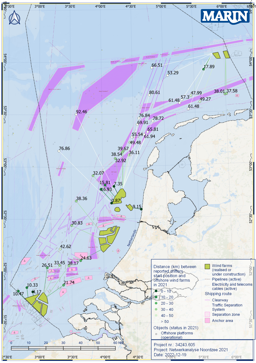
In addition to normal shipping patterns, the project includes gathering information on ‘deviant’ behaviour such as vessels that are adrift or the impact of bad weather conditions. Over the past five years for example, an average of 56 vessels per year were reported to the Coastguard as ‘Not Under Command’ Yvonne points out. These vessels pose a potential threat in relation to future wind farms. In the most recent analysis MARIN looked at the distance between the drifting vessels and the proposed and existing wind farm locations. In 2021, the smallest distance between the starting location of the vessels “NUC” and proposed wind farm locations was just 0.5 NM. The shortest distance to an operational wind farm was 2.3 NM.
Combining weather conditions and AIS data
“During severe weather conditions vessels need enough free space to manoeuvre safely. By combining weather conditions and AIS data (sailing track), we can examine how much manoeuvring space vessels used in the past during more challenging conditions.” This information is extremely relevant for the future spatial design of the North Sea and provides insight to determine the necessary safety margin between the main shipping routes and wind farms, Yvonne stresses.
MARIN and the RWS will continue to gather this vital information about movements on the North Sea to ensure the safety of shipping in a rapidly changing environment. Detailed reports will be made available on the MARIN website.
MARIN Risk assessments and safety studies
More info:


MARIN Risk assessments and safety studies
June 2023, no. 136
Report
Yvonne Koldenhof,
team leader Traffic & Safety
More info:
Figure 2. Location and distance between drifters and OWP in 2021 (existing or under construction).
In addition to normal shipping patterns, the project includes gathering information on ‘deviant’ behaviour such as vessels that are adrift or the impact of bad weather conditions. Over the past five years for example, an average of 56 vessels per year were reported to the Coastguard as ‘Not Under Command’ Yvonne points out. These vessels pose a potential threat in relation to future wind farms. In the most recent analysis MARIN looked at the distance between the drifting vessels and the proposed and existing wind farm locations. In 2021, the smallest distance between the starting location of the vessels “NUC” and proposed wind farm locations was just 0.5 NM. The shortest distance to an operational wind farm was 2.3 NM.
Combining weather conditions and AIS data
“During severe weather conditions vessels need enough free space to manoeuvre safely. By combining weather conditions and AIS data (sailing track), we can examine how much manoeuvring space vessels used in the past during more challenging conditions.” This information is extremely relevant for the future spatial design of the North Sea and provides insight to determine the necessary safety margin between the main shipping routes and wind farms, Yvonne stresses.
MARIN and the RWS will continue to gather this vital information about movements on the North Sea to ensure the safety of shipping in a rapidly changing environment. Detailed reports will be made available on the MARIN website.
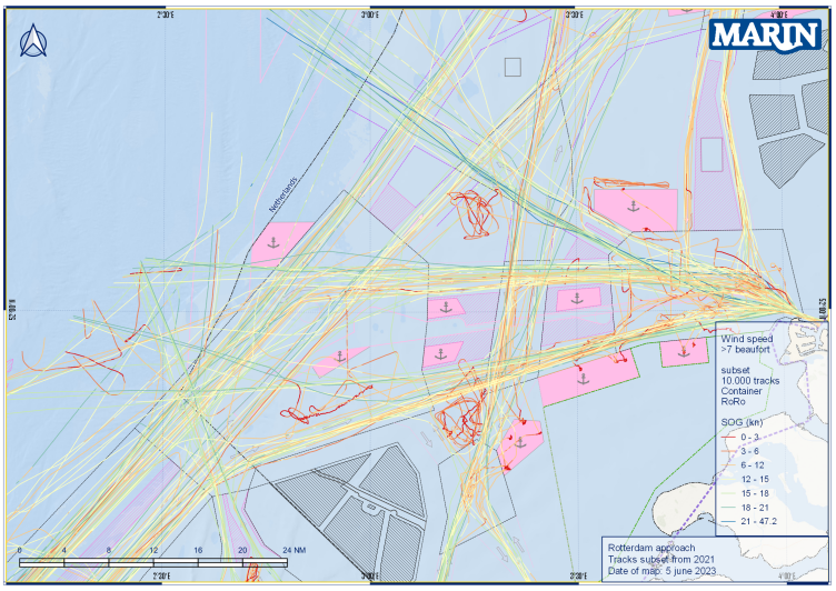
Figure 1. Deviating tracks of ships during Beaufort wind force >7 off the coast near Rotterdam.
Implications for safety
Further research into shipping traffic is crucial when looking at the latest figures. “Approximately 245,000 ship movements were observed in 2021 alone in the Dutch EEZ. And, despite the COVID pandemic, the total number of ship passages on the main routes increased by 1.5% compared to 2018/2019,” Yvonne emphasises. The analysis of the shipping density and intensity also showed that more vessels sailed through the so-called deep-water route on the west and north side of the main traffic system of the Dutch EEZ, she adds. However, there was a decrease of movements by passenger and recreational vessels, probably caused by COVID-19 measures, at the port entrances of IJmuiden, Rotterdam and the Western Scheldt.
This will have a significant impact on life at sea, from the wind and current patterns and ecosystems, to the shipping movements.
Over the past decade MARIN has monitored maritime traffic on the North Sea by analysing Automatic Identification System (AIS) data provided by the Netherlands Coastguard. Team Leader Traffic & Safety Yvonne Koldenhof comments: “We are delighted to announce that our successful collaboration with the Rijkswaterstaat (RWS) (part of the Dutch Ministry of Infrastructure and Water Management) is set to intensify through a five-year project where we are monitoring the shipping movements as the North Sea changes and evolves due to the increase in activities offshore.” This is the part of RWS’s wide-reaching MOSWOZ Monitoring and Research Programme, which is studying shipping safety related to offshore wind.
This cooperation between RWS and MARIN is particularly important given the growing development of wind farms at sea and the increasing levels of shipping activity, she adds. MARIN’s research will consider the implications for the safety of shipping, including the effectiveness of different measures already in place such as the use of Emergency Response and Towing Vessels.
In the coming years the North Sea will change dramatically due to the development of additional offshore activities such as wind farms, other forms of energy and food production.
Monitoring shipping on the changing North Sea