March 2025, no. 143
Create a MARIN account to stay updated


Report
Complex simulations explore inland navigation on the Gelderse IJssel
Climate change is causing more frequent periods of drought, leading
to low water levels in this river system. This makes it challenging to guaranteeing cargo transport via inland waterways.
The maximum permitted ship dimensions on this route are 110 m long and 12 m wide. However, currently the upstream part of the Gelderse IJssel does not meet the requirements to allow ships of such dimensions to transit the waterway normally. Therefore, it is necessary to impose an encountering and overtaking ban on several parts of the river for ships longer than 80 m and wider than 9.5 m. Even smaller ships can at times barely navigate the upstream part of the river during low river discharge.
The Dutch Ministry of Infrastructure and Water Management (Rijkswaterstaat) asked MARIN to examine the limits of navigability of the upstream part of the river between Westervoort and Deventer. These research results are needed to decide on measures to keep the Gelderse IJssel safely and optimally navigable in the future. This includes necessary decisions regarding bed level maintenance and changes in discharge distribution within the framework of the Integrated River Management (IRM) programme.
Study on limits of navigability
To investigate the limits of navigability of the Gelderse IJssel, the focus was on the location and severity of bottlenecks for different bed level scenarios and river discharges. This was studied for situations with normal, low, and extremely low discharge. As a first step, MARIN evaluated the course and width of the upstream part of the river using the Rijkswaterstaat Waterway Guidelines 2020. The differences of the actual condition of the riverbed and the situation 20 years ago have been identified to find key trends.
The next step involved mapping the actual manoeuvring behaviour of the vessels on the Gelderse IJssel. To this end, an analysis of Automatic Identification System (AIS) data and a nautical study using real-time simulations were conducted to investigate bottlenecks in the safe passage of shipping traffic under different discharge conditions. During the simulations at the MARIN Seven Oceans Simulation centre the skippers, all having knowledge of navigating rivers with limited space, were examined by our human factor specialists to address the human controllability of encountering ships in a bottleneck of the river. The results of the sub-studies were combined into conclusions and recommendations regarding navigability and admission policy.
Key findings and conclusions
It can be concluded that safe encountering on the upstream part of the Gelderse IJssel during extremely low discharge is mostly restricted by the width of the fairway and highly dependent on good mutual agreements and the knowledge the skippers have of the route. When the agreement of the encounter manoeuvre is good and timing is precise, there is still enough space to safely pass on straight sections and in bend transitions, even for the longest ships. Smaller ships can still safely meet each other everywhere along the river at all the river discharges MARIN investigated, but overtaking is no longer possible at extremely low discharges. Safety is highly dependent on local knowledge, communication, and the skills of the skippers.
The available water depth, and therefore the maximum loading depth of the ships, is becoming increasingly limited. As a result, the ships can carry less and less cargo. To guarantee adequate water levels for goods transport via the Gelderse IJssel it is recommended to reconsider the discharge distribution between the Waal, Rhine/Lek, and IJssel rivers.
Complex study gains important knowledge for a navigable future
The Gelderse IJssel is a difficult river to model for real-time simulations, given its complex underlying physical phenomena. It is not a canal with a square cross-section. It has a lot of bends, groynes and a sloping bank. This study was conducted on the edge of what is currently possible in real time simulation, and we are proud of the result.
MARIN is enhancing its understanding of sailing behaviour on restricted inland waterways to obtain validated results and to ensure our rivers remain navigable in the future.
The situation of the Gelderse IJssel in the Netherlands is even more complicated due to soil erosion, changing morphological conditions of the bottom, and the shift in discharge distribution (feed of water) between the Waal, Rhine/Lek, and the IJssel. These factors have worsened over the years.
During low river discharges, the available width of the navigation channel of the upstream part of the river between Westervoort and Deventer is locally reduced from 40 m to 25, or even 20 m at some spots. Additionally, the strong meandering character with deep water outer bends and shallow water inner bends make the IJssel even more challenging to navigate under low discharge conditions.
Encountering ships in the Upper IJssel. Created from AIS data from RWS using the temporal controller in QGIS and ffmpeg. Purple ships are sailing with a drift angle, yellow ships are missing the heading and are drawn with the course over ground.
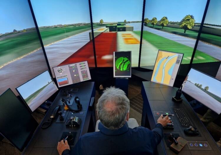
The skipper’s perspective during the simulation.

Interested? Contact us to discuss your options
“Even smaller ships can at times barely navigate the upstream part of the river during low river discharge.”

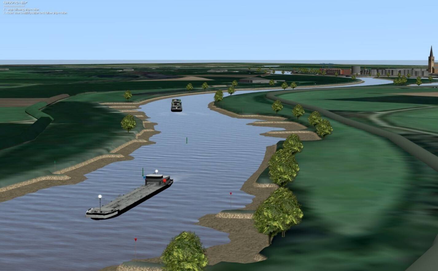
Visual representation of the Gelderse IJssel river flowing towards Doesburg.


Frederieke Doorn
Project Manager


Encountering ships in the Upper IJssel. Created from AIS data from RWS using the temporal controller in QGIS and ffmpeg. Purple ships are sailing with a drift angle, yellow ships are missing the heading and are drawn with the course over ground.
Frederieke Doorn
Project Manager
The skipper’s perspective during the simulation.
Key findings and conclusions
It can be concluded that safe encountering on the upstream part of the Gelderse IJssel during extremely low discharge is mostly restricted by the width of the fairway and highly dependent on good mutual agreements and the knowledge the skippers have of the route. When the agreement of the encounter manoeuvre is good and timing is precise, there is still enough space to safely pass on straight sections and in bend transitions, even for the longest ships. Smaller ships can still safely meet each other everywhere along the river at all the river discharges MARIN investigated, but overtaking is no longer possible at extremely low discharges. Safety is highly dependent on local knowledge, communication, and the skills of the skippers.
The available water depth, and therefore the maximum loading depth of the ships, is becoming increasingly limited. As a result, the ships can carry less and less cargo. To guarantee adequate water levels for goods transport via the Gelderse IJssel it is recommended to reconsider the discharge distribution between the Waal, Rhine/Lek, and IJssel rivers.
Complex study gains important knowledge for a navigable future
The Gelderse IJssel is a difficult river to model for real-time simulations, given its complex underlying physical phenomena. It is not a canal with a square cross-section. It has a lot of bends, groynes and a sloping bank. This study was conducted on the edge of what is currently possible in real time simulation, and we are proud of the result.
MARIN is enhancing its understanding of sailing behaviour on restricted inland waterways to obtain validated results and to ensure our rivers remain navigable in the future.
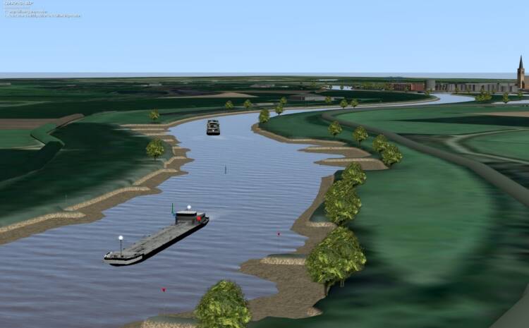
Visual representation of the Gelderse IJssel river flowing towards Doesburg.
“Even smaller ships can at times barely navigate the upstream part of the river during low river discharge.”
The maximum permitted ship dimensions on this route are 110 m long and 12 m wide. However, currently the upstream part of the Gelderse IJssel does not meet the requirements to allow ships of such dimensions to transit the waterway normally. Therefore, it is necessary to impose an encountering and overtaking ban on several parts of the river for ships longer than 80 m and wider than 9.5 m. Even smaller ships can at times barely navigate the upstream part of the river during low river discharge.
The Dutch Ministry of Infrastructure and Water Management (Rijkswaterstaat) asked MARIN to examine the limits of navigability of the upstream part of the river between Westervoort and Deventer. These research results are needed to decide on measures to keep the Gelderse IJssel safely and optimally navigable in the future. This includes necessary decisions regarding bed level maintenance and changes in discharge distribution within the framework of the Integrated River Management (IRM) programme.
Study on limits of navigability
To investigate the limits of navigability of the Gelderse IJssel, the focus was on the location and severity of bottlenecks for different bed level scenarios and river discharges. This was studied for situations with normal, low, and extremely low discharge. As a first step, MARIN evaluated the course and width of the upstream part of the river using the Rijkswaterstaat Waterway Guidelines 2020. The differences of the actual condition of the riverbed and the situation 20 years ago have been identified to find key trends.
The next step involved mapping the actual manoeuvring behaviour of the vessels on the Gelderse IJssel. To this end, an analysis of Automatic Identification System (AIS) data and a nautical study using real-time simulations were conducted to investigate bottlenecks in the safe passage of shipping traffic under different discharge conditions. During the simulations at the MARIN Seven Oceans Simulation centre the skippers, all having knowledge of navigating rivers with limited space, were examined by our human factor specialists to address the human controllability of encountering ships in a bottleneck of the river. The results of the sub-studies were combined into conclusions and recommendations regarding navigability and admission policy.
The situation of the Gelderse IJssel in the Netherlands is even more complicated due to soil erosion, changing morphological conditions of the bottom, and the shift in discharge distribution (feed of water) between the Waal, Rhine/Lek, and the IJssel. These factors have worsened over the years.
During low river discharges, the available width of the navigation channel of the upstream part of the river between Westervoort and Deventer is locally reduced from 40 m to 25, or even 20 m at some spots. Additionally, the strong meandering character with deep water outer bends and shallow water inner bends make the IJssel even more challenging to navigate under low discharge conditions.
Climate change is causing more frequent periods of drought, leading
to low water levels in this river system. This makes it challenging to guaranteeing cargo transport via inland waterways.
Complex simulations explore inland navigation on the Gelderse IJssel
Msrch
2025, no. 143
Interested? Contact us to discuss your options

Create a MARIN account to stay updated
Report


